Wednesday, November 21, 2018

Hardy Ridge

Date hiked: 11/20/18

In case this hasn't been made clear, I got very lucky with moving to Portland when I did--the weather has been unusually mild this autumn. My co-worker at NewEra commented that this is the driest November that she can remember. That being said, I realize that my luck might be up soon, so I squeezed in one more hike before the holiday.

On Tuesday, I returned to Beacon Rock State Park on the Washington side of the Gorge. The Equestrian Trailhead is located off lovely Highway 14, just 50 minutes east of town. Hardy Ridge is a lightly-trafficked, moderate 8.1 mile loop over 2,200' elevation gain.

I set off at 11am, hiking north on the Equestrian Trail for a mile. At the first junction, I continued another half mile to turn onto the East Hardy Ridge Trail, lined with salmonberry bushes. A connector trail leads to a four-way junction at the top of the ridge. I climbed a bit higher to snag some unobstructed views, but the high winds prevented me from reaching the true summit. Still, I got a glimpse of Hamilton Mountain, Table Mountain, Mt. Adams, and Mt. Hood.


Back at the junction, I completed the loop in a counter-clockwise direction by taking the connector trail down the western side of the ridge. End: 2pm. I met Kyle afterwards for happy hour eats and drinks at my new favorite vegan bar, The Sweet Hereafter.

Tuesday, November 20, 2018

Salmon Butte

Located 15 minutes from downtown, Tryon Creek State Natural Area is Oregon's only state park within a major metropolitan area. Tryon Creek meanders through 658 acres of lush, second-growth forests, serving as home to a variety of flora and fauna. A small network of trails, including a wetland boardwalk, are serviced by hikers, equestrians, and cyclists. A new friend from the vegan community, Chloe, and I explored the area on an overcast weekday morning.


That weekend, I met up with my friend, Jordan, visiting from Denver. I thoroughly enjoyed seeing a friend from "home." We hit Virtuous Pie, my new go-to pizza joint, as well as three nearby breweries (#11): Hair of the Dog Brewing Company, Cascade Brewing (mostly sours) and Base Camp Brewing Company (a new favorite).


The Salmon Butte Trail is one of the more popular trails in the Salmon-Huckleberry Wilderness. Located one hour southeast along Highway 26 (near Welches), the moderate out-and-back route gains 3,170' over 11.5 miles. It is a mostly shady forest hike with a few small clearings.

Kyle and I got a late start on Sunday, leaving the trailhead at noon. We crossed the bridge over the Salmon River and followed the old road bed shaded by red alder, big-leaf maple, western red-cedar and western hemlock. There are several creeks to cross before entering a dense, dark woodland filled with large old-growth trees. We noted the silence of the forest during this time of year, deepened by the fact that we had the trail to ourselves.

The trail eventually rounds the nose of the ridge at a small opening and traverses up a slope in the Mack Hall Creek drainage. A steep sunny meadow affords a view across to Salmon Mountain and ahead to Salmon Butte.

We continued to ascend via switchbacks before bearing right on an old road bed in an avenue of rhododendrons (June blossoms). The final push to the open summit (4,877') is rewarded by a full-on view of Mt. Hood. Expansive vistas abound with Mt. Jefferson and the Three Sisters to the south, and Mt. Hood, Mt. Adams, Mt. St. Helens, Mt. Rainier and the Salmon River valley to the north.


Date hiked: 11/18/18
Realizing we only had about two hours left until sunset, Kyle and I booked it back to the trailhead. We arrived at 4:30p with just enough daylight to spare---4.5 hours RT! On the way back, we feasted at a Lebanese restaurant in Gresham. 

Coastal Road Trip

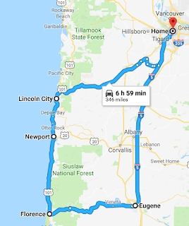
I recently took advantage of a long weekend road-trip style. In no particular rush, Little Red and I took off Sunday morning tracking southwest to the coast. The tentative plan was a three-day trek down the coastline, then circling back through Eugene.

11/11/18-11/13/18
Sunday: Lincoln City
The first leg of my trip began with coastal hiking just north of Lincoln City. Along the way, I passed the Drift Creek Covered Bridge. Restored (and relocated), it is the oldest covered bridge in Oregon.


After two hours of driving, I was ready to stretch my legs. Hart's Cove Trail is a lesser known hike located in the Siuslaw National Forest. The moderate out-and-back route gains 1,000' over 5.4 miles. I set off around 12pm, switchbacking 
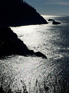
downhill through a young coastal forest. Beyond the Cliff Creek Bridge, the trail levels and the forest becomes older (more than 250 years). After another mile, I rounded a bend to find a bench that offered the first glimpse of Hart's Cove. The proximity to the cove was confirmed by the sounds of barking sea lions on the beaches below.


The end of the hike opens into a wide meadow with beautiful sea views, including Hart's Cove and a waterfall where Chitwood Creek cascades onto the beach. I was reluctant to leave the warmth of the sunshine, but eventually returned to the shady forest and trailhead around 2pm.

Date hiked: 11/11/18
The hike to God's Thumb can be reached by two routes. The more scenic option is a 4.4-mile loop that combines roads, forest and beach. I left the parking lot at Road’s End State Recreation Site around 3:15pm.


Initially, a bit of road-walking leads to a forested trail. A brief but steep climb to a junction offers the first stunning vista from “The Knoll.” Back at the junction, I continued north for about a mile to a grassy meadow with sweeping coastal views.


The trail drops down along the edge of a cliff, into the vast meadow that surrounds God’s Thumb.


The climb to the top is very steep (and windy), but the views are incredible: to the north, Cascade Head juts out into the ocean; to the south, steep cliffs, meadow and Lincoln City spread out below.


Eventually, I began to slowly track downhill, following the lower trail through the meadow and into the forest. The final mile along Logan Road leads back to Road’s End, but a better option is to drop down through a beach access point and walk along the beach. End: 5:15pm.


Date hiked: 11/11/18
Monday: Newport
Aunt Judy generously hooked me up with lodging at 
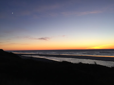
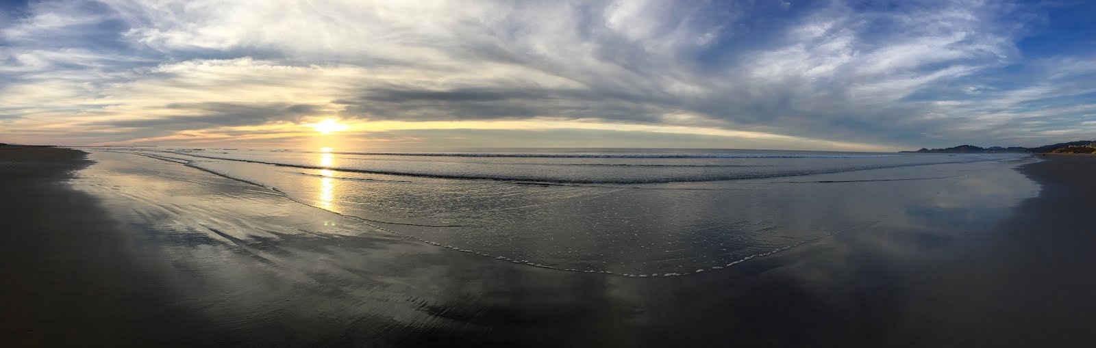
Inn at Nye Beach in Newport. I was eager to spend the day exploring the quaint town on Oregon's central coast, counting my blessings for another beautiful day of warm sunshine and fresh sea air. It was an added bonus to visit during the quiet off-season.

Just north of town, the Yaquina Head Outstanding Natural Area is one of the best-managed and most beautiful parks on the Oregon coast. Several short trails stem from the expansive Interpretive Center.


The crown jewel of the park is the 93' tower located on a narrow point of land jutting nearly a mile into the Pacific Ocean. It took about a year, and over 370,000 bricks, to build Oregon’s tallest lighthouse in 1872.


Just below the cliffs at the lighthouse, Cobble Beach is worth a visit to examine the tide-pool wildlife.


A short hike to the top of Salal Hill offers views of the entire head.


Quarry Cove used to be an old rock quarry, repurposed into an intertidal area in the early 1990s. Low tide is the best time to visit.


Tracking south, my next stop was Agate Beach.


Located at the mouth of the Yaquina River, the Yaquina Bay State Recreation Site is home to another historic lighthouse. Built in 1871, the Yaquina Bay Lighthouse is the only wooden Oregon lighthouse still standing. The restored lighthouse is listed in the National Register of Historic Places.


Gazing far off shore, the friendly site volunteers helped me spot my first whales! Best viewing of the migrating gray whales is between December and March, so I was not expecting to see them on this trip, but it appears that once you see one spout, you see them all. Though observed more clearly through binoculars, it's possible to see the shiny bodies of the breaching whales without aid.


The site is also a great place to regard one of the most recognizable bridges on the Oregon Coast. The historic Yaquina Bay Bridge, designed by Conde McCullough, spans 3,260' between downtown Newport and the South Beach area. 


Newport's Historic Bayfront is a popular destination for shopping, seafood, and sea lions.


After stocking up on chocolate-dipped "seafoam" (aka honeycomb or sponge candy), I circled back to Nye Beach for another perfect West Coast sunset. Learning to surf is climbing higher and higher on my Oregon bucket list...


Tuesday: Florence + Eugene
Though partly cloudy, the temperatures were still pleasant on the final day of my trip. I packed up Red and continued south on U.S. Route 101. Several stops are merited along this famous scenic byway.


The Hobbit Trail is a must-do. Leave your car at the trailhead along the highway and immediately become immersed in a deep and luscious coastal forest, lined with Sitka spruce and rhododendrons. The short but steep trail leads to a beautiful secluded beach.


The Heceta Head Lighthouse State Scenic Viewpoint is another popular stop.


A short path begins from the beach to the Light Keeper's home (now a B&B and event rental) and to the lighthouse perched on a cliff 205' above the ocean. First illuminated in 1894, the lighthouse casts its beam 21 miles out to sea. It is the brightest light on the Oregon coast.


I passed up a visit to the Sea Lion Cave as I caught wind that they were currently out to sea.


Florence is a small city at the mouth of the Siuslaw River. Shops and galleries fill the Historic Old Town district. Across the river are the towering sand mounds of the Oregon Dunes National Recreation Area.


One of the big draws to moving to Portland was the fact that I could theoretically see the ocean and mountains in the same day. In order to prove this speculation, I left the coast and traveled an hour east towards Eugene. The trek to Spencer Butte is a challenging 784' climb via a 1.7 mile loop. This popular backdoor hike is part of the Ridgeline Trail System.


The 360-degree vista from the summit extends up the Willamette Valley, west to the Coast Range, and to the central Cascades peaks of the Three Sisters. RT 2:45pm-3:45pm.


Date hiked: 11/13/18
While I had hoped to walk through the University of Oregon campus afterwards, the setting sun took with it the last of my energy reserves. The exhaustion from my action-packed road trip sunk in as I made the two-hour drive north to Portland. Nevertheless, I am confident that there will be future opportunities to visit Eugene. Central, southern and eastern Oregon are up next!

Grateful for the opportunities and time well spent these three days.