I took a week off from work in mid-August to explore Mt. Rainier National Park (MRNP). The road trip was shortened by two days due to an unusual turn of cool/wet weather, but I still squeezed in plenty of hiking. While I could likely write a short novel about my journey, for the sake of time, I will instead include only the highlights--and very best pictures--from each day. Full hiking descriptions can be found by following the corresponding web links.
 |
| 8/12-8/17 |
MRNP is located in west-central Washington. It's a three hour drive from Portland, but the five developed areas of the park are widely spread out along two-lane winding roads. Mt. Rainier (14,410') is the most glaciated peak in the lower 48 states, spawning five major rivers. Subalpine wildflower meadows ring the icy volcano, while ancient forest cloaks its lower slopes. Native Americans used the natural resources surrounding the mountain they called "Tahoma" 9,000 years ago. Unlike walk-up peaks such as Mt. St. Helens and Mt. Adams, a Rainier climb requires technical skills and mountaineering gear--and an elevation gain of 9,000'! P.B. Van Trump and General Hazard Stevens recorded the first documented ascent in 1870.
Date hiked: 8/12/19
Trailhead: Berry Patch (Goat Rocks Wilderness)
Stats: 13-mile loop, 1,900' gain, 6,500' max
Synopsis: An alpine ramble that features cool forest, vast wildflower fields, high alpine meadows, icy lakes/streams, and stunning panoramas of several Cascades volcanoes (Mt. Rainier, Mt. Adams)
Highlights:
-15.5-mile dirt road to trailhead
-Watch for mountain goats; birds and butterflies also plentiful
-Very long day hike--consider backpacking to fully appreciate beauty
-Crowded on weekends
TUESDAY (DAY 2):
Spray Park
Date hiked: 8/13/19
Trailhead: Mowich Lake (northwest MRNP)
Stats: 8-mile out-and-back, 1,700' gain, 6,500' max
Synopsis: Two-mile forested stroll across several falls/streams, followed by steep switchbacks to open meadows with wildflowers and views of Mt. Rainer, Echo Rock and Observation Rock
Highlights:
-17-mile dirt road to trailhead
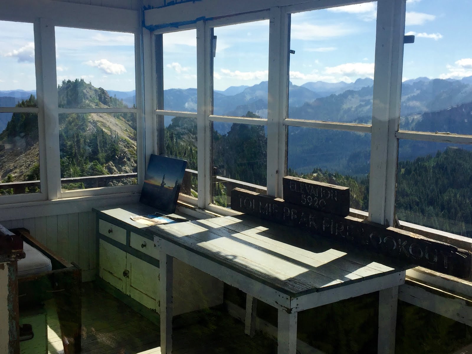
Trailhead: Mowich Lake (northwest MRNP)
Stats: 7.5-mile out-and-back, 1,100' gain, 5,900' max
Synopsis: First three miles through graded, old-growth forest leads to sapphire blue Eunice Lake; final mile is a steep climb to an old fire lookout atop Tolmie Peak with commanding views of Mt. Rainier and the Carbon River Valley
Highlights:
-17-mile dirt road to trailhead
-Go early to avoid crowds, heat and bugs; also consider for sunrise/sunset
Beautiful weather graced this hike. Unfortunately, I was eaten alive by mosquitos. 9:30am-1:30pm RT.


 THURSDAY (DAY 4)
:
Skyline Trail Loop
Date hiked: 8/15/19
Trailhead: southwest MRNP (Paradise)
Stats: 5.5-mile loop, 1,450' gain, 6,800' max
Synopsis: Peak season trips (July/August) yield views of cascading waterfalls, mighty glaciers and subalpine meadows brimming with colorful splashes of wildflowers
Highlights:
-
Paradise is the most popular area of the park; go early
-Southern exposure extends hiking season past that of north side counterpart, Sunrise
Date hiked: 8/16/19
Trailhead: Narada Falls (southwest MRNP)
Stats: 5-mile loop, 1,150' gain, 5,400' max
Synopsis: A loop featuring an unobstructed view of the Tatoosh Range from a rocky bluff, and an up-close experience of the whitewater cascades of the Paradise River
Date hiked: 8/17/19
Trailhead:White Pass/Cowlitz River Valley (Gifford-Pinchot National Forest)
Stats: 3.2-mile out-and-back, 1,365' gain, 5,685' max
Synopsis: A short climb along Sawtooth Ridge to a fire lookout cabin that clings to the top
Highlights:
-Several miles of dirt road to trailhead
-Moderately steep with few switchbacks
-A close-up look of Mt. Rainier is the main attraction, but views extend to Mt. Adams, Mt. Hood and Mt. St. Helens
Another foggy morning, but a worthwhile experience nonetheless!


Date hiked: 8/17/19
Trailhead: Tipsoo Lake (southeast MRNP)
Stats: 3.2-mile loop, 600' gain, 5,850' max
Synopsis: A short loop provides a range of alpine experiences, including stunning views of Mt. Rainier
Highlights:
-Follow the loop clockwise via Naches Peak Trail and Pacific Crest Trail
-Crowded
-Seasonal wildflowers and huckleberries
Tom joined for the Saturday hikes--a welcomed change from my week of solitude!


What a week! Based on my initial impression, MRNP seems more wild and rugged than other areas of the PNW. It's therefore wise to have a back-up plan--for navigation, especially--if and when technology/cell reception fails. A major take-away of the trip was gracefully managing disappointment when weather didn't cooperate.
Who would have predicted questionable weather in August? There will always be factors beyond our control; in these situations, it's best to remain patient and present, stay flexible and keep expectations low. Above all, remember
gratitude.
A note about lodging: I stayed at a mix of airbnb venues throughout the week--an eclectic craftsman house in Enumclaw, a haunted school house in Mineral and an RV in Ashford! While this allowed me certain comforts and novelties--and a more intimate experience in each town--I could have saved a substantial amount of time and money by camping. I still don't have the proper overnight gear, but I could have significantly reduced driving time (750 miles!) by at least sleeping in my car during the nights that I embarked from the same trailhead on consecutive days. Furthermore, camping facilitates a complete connection to nature from sunup to sundown, including opportunities for stargazing...