Wednesday, July 21, 2021

Chinidere Mountain

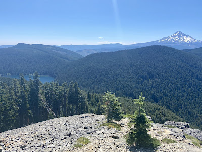
The week after the annual Cathedral Park Jazz Festival, I hiked to Chinidere Mountain, a 4.4-mile trek (1,140' gain) in the Mark O. Hatfield Wilderness that features a lake, wildflowers and mountains.


Wahtum Lake Trailhead is 1.75 hours east of Portland, with the second half of the drive through back roads; the last 10 miles are especially long, on a narrow winding road. The trip was worth it though, as I had the trail to myself apart from a few campers at Wahtum Lake. From the trailhead, take the Wahtum Horse Route on an easy 0.4-mile descent to the Pacific Crest Trail, near the lake shore.


Turn right on the PCT, and hike through the forest as the trail gradually curves above the lake, circling the east shore. The trail pulls away from the lake towards a junction with the Herman Creek Trail at 2 miles.


Continue on the PCT to the junction with Chinidere Mountain and begin climbing a series of steep, irregular switchbacks for 0.4 miles. As the route nears the summit, a couple of side trails lead to wildflower meadows (June/July) with views into Eagle Creek canyon. 


Finally, the trail circles the platy andesite slopes of the summit before ascending to the top (4,673'). An unobstructed 360-degree view includes the major Cascade volcanoes--Mts. St. Helens, Rainier, Adams, Hood, Jefferson--with Wahtum Lake shimmering below.


The return trip follows the summit path back down to the PCT, then backtracks the short distance to the Chinidere Cutoff Trail. From there, the route drops quickly to a small stream crossing, and through loose switchbacks. The trail levels off in a traverse toward Wahtum Lake that follows an old water supply line. Soon, the route reaches the outlet to the lake, the East Fork of Eagle Creek, which can be crossed by hopping logs.


On the far side of the outlet, the trail reaches the Eagle Creek-Chinidere Cutoff Trail junction. Turn left and rejoin the PCT at the 4-mile mark. Pass more campsites and lake views before reaching the spur back to the trailhead. Note that this log describes a counterclockwise approach, but I would try it clockwise next time for a slightly steeper ascent and gradual descent. Pack bug spray.

Hiked 7/20/21 - 1.5 hours

Thursday, July 15, 2021

Tamanawas Falls, Umbrella Falls, Sahale Falls

On a free Wednesday, little Red and I chased waterfalls on Mt. Hood. About 1.5 hours from home, Tamanawas Fall Trailhead lies off Highway 35. The  popular trek to Tamanawas Falls is an easy 3.4-mile out-and-back (560' gain). 

East Fork Trail #650 begins in the woods and crosses the East Fork of the Hood River. The trail climbs gradually before rounding the corner into Cold Spring Creek canyon. Then the path drops down towards Cold Spring Creek. East Fork Trail continues north, and offers a less crowded route to the falls from Polallie Trailhead. 

The Tamanawas Falls Trail ambles upstream, tumbling over a series of tiny waterfalls. At 1.5 miles, the path climbs through a large boulder field. Beyond the rockfall, the trail enters forest and soon arrives at an upstream view of Tamanawas Falls, which form a broad curtain where Cold Spring Creek thunders over a 110' lava cliff near the eastern base of Mt. Hood. 


Hiked 7/14/21 - 1 hour

7.5 miles away on Highway 35, Elk Meadows Trailhead is one possible starting place to reach Umbrella Falls and Sahale Falls. The easy 4-mile lollipop loop (840' gain) travels below Mt. Hood Meadows ski area.

I hiked the loop counterclockwise, beginning on the Umbrella Falls Trail. The trail climbs around a rocky bluff, eventually opening up to Hood River Meadows spread out below. The path continues upward toward Mt. Hood, crossing several small creeks with a beautiful display of wildflowers in July and August.


Staying straight through a junction nearing the 2-mile mark leads to graceful Umbrella Falls. 


I backtracked to the junction and turned right on the forested Sahale Falls Trail, descending alongside the East Fork that plunges down a narrow canyon.


At a fork, a steep scramble leads down to the base of Sahale Falls (not recommended for small children or pets). Back on the main trail, I finished the last half mile to the trailhead.

Hiked 7/14/21 - 1.25 hours

Wednesday, July 7, 2021

Eagle Creek to Tunnel Falls

Summer was in full swing by July. Tom and I kicked off July 4th weekend with Matt and Katie's wedding at the Empress Estate in Woodland, Washington.


On Saturday, I joined Kyle and his friends for a float down the Sandy River. Just east of Troutdale, the river is fed by Mt. Hood’s Sandy Glacier. Our group organized a shuttle system for the 4-mile section between Dabney State Recreation Site and Lewis and Clark State Recreation Site. Even with occasional stops, the mellow section of river only takes about 2-4 hours to complete. It was the perfect summer activity, and I look forward to doing it again!

Please drink responsibly

On Monday, I returned to I-84 east to hike Eagle Creek to Tunnel Falls. Recently reopened after the detrimental 2017 Eagle Creek Fire, the trailhead is a 40-minute drive from Portland. I was excited to finally check out this popular area of the Gorge.

The easy out-and-back follows the creek into a moss-covered old growth forest, crossing many side-creeks, footbridges and steep cliffs. I suspect that the path was once shaded, but the fire has left it quite exposed; note that this trail can get very hot and very crowded.


At about the 2-mile mark, a side trail drops down to Punch Bowl Falls. The High Bridge lies another mile further.


After about 6 miles, the path passes through a tunnel behind--you guessed it--Tunnel Falls. The 175' cascade drops from the bluffs above to the creek bed below, then downstream into the main Eagle Creek run.


Two-tiered Twister Falls lie just up ahead. The trail continues on to Wahtum Lake and syncs up with other trails, which provides several backpack options that pass through Eagle Creek.

Hiked 7/5/21 - 12 miles, 1,100 vertical feet - 3.5 hours

Later that week, a longing for the mountains prompted me to drive up to Mt. Hood for a paddle. The snow on top of the mountain was already melted--early for the season. Timothy Lake is a large alpine lake surrounded by pine trees. A 13-mile trail winds around the lake shore, connecting several campgrounds. Note to check wind conditions before heading out on the water!