
Access to the Inca Trail is limited to 500 people per day, and securing a permit is only possible with an approved tour provider--in our case, G Adventures. A crew of local porters, cooks, and guides arrange the trip details. Pack animals are not allowed on the Inca Trail, so porters carry the majority of the gear. The best time of year to hike is arguably on the shoulder months of the dry (high) season; late April/early May and late September/early October. Book recommendation: Turn Right at Machu Picchu by Mark Adams--if a bit arrogant at times, it is an entertaining read and very informative.
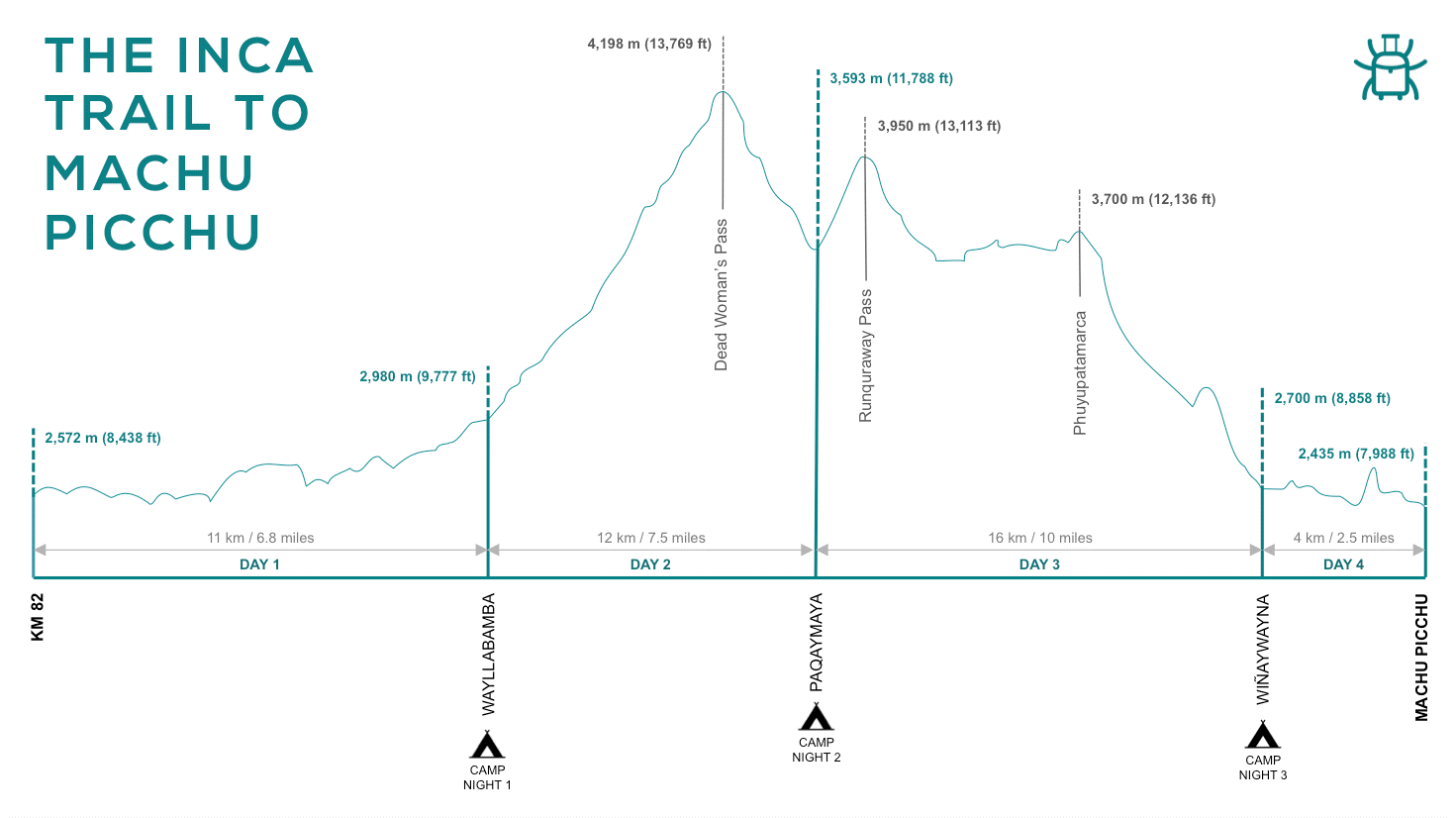
Day 1: Ollantaytambo at km 82 – Wayllabamba Camp
Distance: 6.8 miles (+1,150')Time: 5-6 hours


Wednesday was our hardest day of trekking, with close to 4,000' of elevation gain. Much of the trail consists of an infinite series of large, stone steps. Unlike the day before, the group was allowed to disperse in order to hike at various paces, ultimately reuniting at designated rest areas.


Day 4: Wiñay Wayna – Machu Picchu
Distance: 3.1 miles


Description: Travel by van from Cusco to Ollantaytambo at km 82 where the Inca Trail begins. Ease into the adventure with a straightforward day of hiking the meandering streams, stunning Andean scenery, and ancient Incan ruins like Llactapata ("hummingbird" in Incan language, Quechua).
We were meant to leave Tuesday morning, but due to potential road closures from the protests in Cusco, our guide made a last-minute change to leave Monday night. Tom and I met our tour group at the Prisma Hotel with shared surprise regarding the sudden change. As quickly as possible, we weighed our bags and loaded up the van. We left for Ollantaytambo at 10:30pm, driving two hours to the beginning of the Inca Trail. Luckily, we only hiked a few minutes in the dark before reaching our first unofficial campsite. Amazingly, the porters already had the camp set up, so Tom and I climbed in our tent and fell asleep.
We woke up in the morning to the sound of roosters. Having been unable to see the scenery when we arrived the night before, I was amazed to unzip our tent; it felt surreal to wake up in the heart of the Sacred Valley of the Incas (Urubamba Valley). At 19,334', Veronica Mountain towered over all else. The best part? It was my 30th birthday!
Our guides, Israel and Uriel, organized breakfast while the hikers anxiously got ready for our first day on the trail. The day warmed up quickly, but we walked slowly with plenty of breaks. We passed several local communities that sell trail supplies and charge a small fee to use the toilet.
We continued along the Urubamba River--a tributary for the Amazon River. The first part of the trail is a desert ecosystem. Israel explained that the Incas used this area for farming and appreciated mother nature. For example, the beetles on cacti were used for sun block and make up, while the seeds from trees' Spanish moss were incorporated into tea infusion to treat throat infections.
During lunch, we continued to get to know our fellow hikers. We were a group of 15, ranging in age from early 20s to late 60s. Nationalities included USA, Canada, UK, and Denmark. I loved the immediate sense of camaraderie and community. Tom and I made fast friends with brothers, Jake and Sam.
Upon reaching Wayllabamba Camp, we freshened up (hello, baby wipes) before dinner. Meals were always slightly different, but consisted of some combination of soup, rice and veggies, fried patties, and something sweet for dessert (vegan options included!). We were well fed and never hungry. Everyone was shocked when the cooks brought out a birthday cake and started singing. Who knew you could bake a cake in a pot over a burner? This was a very special moment that I will remember forever. Having turned 20 in Spain, and 30 in Peru, where might I be at 40?
Day 2: Wayllabamba Camp – Paqaymayo Camp
Distance: 7.5 miles (+3,658')
Time: 6-7 hours
Description: Start early to climb the long steep path to Warmiwañusca (dead woman), which is the highest point of the trek at 13,769'. Reach camp by early afternoon, with ample time to rest and relax.
One stop included a cultural experience to try chicha (corn beer), a traditional Andes homemade sour beer brewed from fermented maize. A red plastic bag on a wooden stick outside the house indicates that the beer is ready for consumption.
We journeyed through progressively spectacular and steeper terrain en route to Dead Woman's Pass. Everyone was impressed (and slightly ashamed) by the porters passing us with significantly heaver loads than us.
When we finally reached the top of the pass, I took in the moment and the view. Under the blazing sun, I reapplied sunscreen and rehydrated. Water is collected from rivers and streams before being boiled at camp each night.
We eventually descended to camp, where I was eager to jump in the river. After dinner that night, I gazed up at the clear sky, admiring the bountiful stars and planets of the southern hemisphere. Sounds of rushing water and animals sang me to sleep. According to Israel, the Incas believed that croaking frogs meant rain was coming...
Day 3: Paqaymayo Camp – Wiñay Wayna
Distance: 9.6 miles (-3,280')
Time: 9 hours
Description: Cross two passes and more ruins on the last full day of hiking. Traverse Runquraway at 13,113', and then the second pass at 12,136'. Spot the snow-capped Cordillera Vilcabamba mountain range and Urubamba Valley in the distance. Camp at the ruins of Wiñay Wayna.
Description: Cross two passes and more ruins on the last full day of hiking. Traverse Runquraway at 13,113', and then the second pass at 12,136'. Spot the snow-capped Cordillera Vilcabamba mountain range and Urubamba Valley in the distance. Camp at the ruins of Wiñay Wayna.
Thursday was our longest day of hiking. The first ruin that we came upon was circular in shape, and likely served as either a watch tower or religious sun temple. Israel explained that the history of the Incas is controversial because they had no written records. Chasquis were dispatched to carry oral messages along thousands of miles of the vast trail network; relay stations were used to transfer messages to the next chasqui. Incas followed three commandments: don't steal, don't lie, and don't be lazy.
Sayacmarca is impressive with its endless layers and powerful spiritual energy. It was theoretically used to store food and supplies, make religious offerings to the snow-capped mountains, and to sacrifice alpacas during the solstices.
On a clear day, some of the best views from the Inca Trail can be seen atop the next pass (which is where we stopped for lunch).
Afterwards, we began our long descent, which was made significantly easier with trekking poles. We first reached the ruins of Phuyupatamarca (town above the clouds). This site was used for farming and astrological purposes. The natural spring is still running over 500 years later, which may have used to bathe before reaching Machu Picchu.
Unlike Western culture, human beings were not regarded as superior to the rest of living beings, but an equal part of a whole, alongside the stars, flowers, birds and the sea. For this reason, the inhabitants of the Andes developed an impressive knowledge of and connection to nature. Incas worshipped the sun, so solstices and equinoxes were sacred dates that also marked agricultural cycles. Their most important buildings were constructed in perfect alignment with these astronomical phenomena.
As we descended from the highlands to the "cloud forest"--where the Andes meets the Amazon--the foliage began to shift from high alpine Andes grass to green moss and bamboo. The humid, rainforest atmosphere reminded me of the Oregon coast.
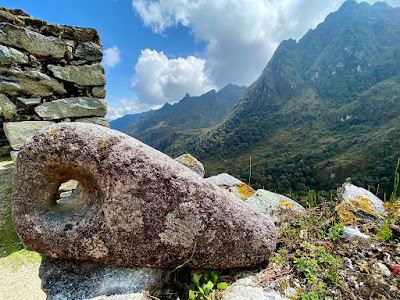
At sunset, we reached the fantastic Wiñay Wayna (forever young) ruins at 8,694'. The site consists of housing complexes connected by a staircase and fountain structures, as well as agricultural terraces. It is built into a steep hillside overlooking the Urubamba River. This is one of the most scenic parts of the trail.

We ultimately found our campsite nearby, feeling nostalgic over our last dinner together and our last night on the trail.
Distance: 3.1 miles
Time: 2-3 hours
Description: Start before dawn to reach the Sun Gate at sunrise. Hike down to Machu Picchu for a guided tour before lunch in Aguas Calientes. Travel to Ollantaytambo by train, and Cusco by van.
The alarm sounded at 3:30am on Friday in order to ensure that the porters could catch their train home. En route to the checkpoint, a brood of cicadas suddenly began chorusing in unison with each other at sunrise.
With much anticipation, we finally glimpsed our first views of Machu Picchu from the Sun Gate. The weather gods were clearly with us on this trip.
Eventually, we hiked down to the ruins for a two-hour tour. As we neared, we were overwhelmed to see so many people after our relative seclusion the past few days. Pro tip: visit in the afternoon to avoid crowds.
The ancient citadel was built in the 1450s in the center of sacred mountains; rhino-horned Huayna Picchu (young mountain) sits directly behind the city, while the neighboring taller peak was named Machu Picchu (old mountain). Apu was the name given to powerful mountain spirits. Machu Picchu remains something of a mystery, but it was built in part as a pilgrimage site, as well as a country estate for Inca ruler, Pachacutec. A natural spring supplied enough water for 500 people, but 5,000 people were theoretically in residence during solstice festivals--the only days of fun and celebration. The granite ruins include residential areas, as well as those dedicated to agriculture, industry, education, and religion. The most important buildings were constructed using jigsaw puzzle masonry, with stones wedged together without mortar; these structures withstood the threat of earthquakes in Cusco while Spanish buildings crumbled. El Torreón, also known as the Sun Temple, served as a solar observatory. The windows align perfectly with the sunrise during the solstices, thereby illuminating the ritual stone (intihuatana) inside. There is evidence that the city's construction was not yet finished when it was abandoned during the Spanish conquest.
On July 24, 1911, Yale University professor Hiram Bingham "rediscovered" the ruins of Machu Picchu (local families were already living there). The site was covered in vegetation, which led to subsequent expeditions to clean and excavate it; the citadel is 75% original today. At the time, Bingham thought that he had found the last refuge of the Incas before the Spanish invasion, the "lost city of the Incas," but it was later discovered to be the ancient city of Vilcabamba. Bingham did not report finding any gold or silver among the ruins at Machu Picchu; grave robbers likely pillaged it before his arrival. It's believed that he inspired the character, Indiana Jones.
After the tour, we caught a bus downhill to the small town of Aguas Calientes. Here we shared our final meal together before departing for the scenic, two-hour train ride to Ollantaytambo.
Finally, we boarded the bus for a two-hour ride to Cusco at sunset's golden hour. Tom and I had booked another bnb that night, but we were so exhausted that we scrapped our plans and stayed at the hotel where we were dropped off. A hot shower and bed awaited us!
Days 9/10: CUZ to PDX
Tom and I slept in on Saturday and grabbed breakfast in Plaza de Armas. We met up with a few people from our group to complete COVID-19 tests for our return flight. Before leaving, Tom and I ate at San Blas's plant-based restaurant Green Point for one of the very best meals (ever); if only we had discovered it sooner. Our flight departed at 9pm that evening, getting us back to our Louie by Sunday afternoon. I feel very grateful for this experience. Next time, should I be so lucky, Salkantay Trail and/or Choquequirao!