Wednesday, September 25, 2019

The Enchantments

I spent last weekend in Leavenworth, WA with five co-workers from OHSU. The 4.5-hour trip follows I-84 E to US-97 N. Diana and I drove into a marvelous sunset on Friday before joining the others at our airbnb. Alarms set for 3:30am, we rested up for the long day ahead. I hadn't started a hike so early since my 14er days in Denver!


The Enchantments is an alpine paradise of granite worn smooth by glaciers, larches manicured by wind and cold, and crystal blue lakes strung together by a creek that tumbles between them. While a handful of backpackers score a lottery-based overnight permit, the majority of visitors complete a 19-mile thru-hike (6,000' gain, 7,800' loss). We parked one car at Snow Lake Trailhead, where we would end the trek, before piling into the second car, which would be dropped at the start--Stuart Lake Trailhead. Armed with headlamps, our group set off shortly after 5am on Saturday. The first section is an easy stroll to Colchuck Lake. Hiking at dawn was surreal, though the moon stayed visible all morning.


Soon after, the route begins climbing steeply over jumbled talus; this is the start of Aasgard Pass. This unforgiving climb rises 2,500' in less than a mile. The path hugs sheer rock opposite Dragontail Peak before traveling through a section of loose rock and scree. The trail can disappear at times, but cairns usually mark the way; following other hikers does not always guarantee the best path. The final push is a scramble over slick boulders, finally topping out at 7,800'. Views stretch from Colchuck Peak and Colchuck Lake to Glacier Peak and Mt. Baker.


The lakes in the Upper Enchantments sit in a stark moonscape of rock, scree and ice below the long ridge culminating in the summit of Dragontail Peak. The trail snakes its way through grey lichen-covered rocks along the shores of Tranquil and Isolation Lakes before dropping steadily to the broad plateau beneath Little Annapurna.


Here the barren rock gives way to a lush alpine meadow, where the creek connecting the lakes meanders gently before tipping into a deeper channel and speeding downhill. We did not encounter any mountain goats along the way, but do not expect to find yourself in solitude on the trek, especially on a fair-weather weekend.


The first larches appear as the plateau ends abruptly in expansive views over Crystal Lake and the Ingalls Creek valley below. Located east of the Cascade crest, larches look like pine trees but their needles turn bright yellow-orange before falling off each autumn.


Inspiration Lake, tucked deep in a basin below Enchantment Peak, marks the beginning of the Middle Enchantments. This area has a distinct fairytale, dreamlike quality. We were very lucky with the weather; clear skies and warm enough to go for a dip in the lakes!


The path descends to Perfection Lake as it passes through tall larches that are several hundred years old.


The route then passes through meadows of grass and over carved inlets leading from Prusik Pass. The view back across the water reveals a stair-step wall of granite over which the main creek cascades down to the lake.


A short while later, the trail climbs slightly and rounds the corner to Sprite Lake, connected to Perfection by a narrow slot of white water.


The Lower Enchantments are marked by the heights of McClellan Peak and Prusik Peak. Under McClellan’s lofty summit sits Leprechaun Lake, an irregular pond draped between ribs of granite topped by dense stands of larches.


Lake Viviane sits in a deep basin below Prusik Peak. The far shore is a wall of rock while its near shore, a smoothed wave of granite where Snow Creek streams down to Snow Lakes. This is the official end of the Enchantments.


The descent to Upper Snow Lake is rugged, including some scramble sections. Snow Creek twists and roars between stands of subalpine firs.


The final section through dark forest follows the Snow Lakes Trail back to the Snow Lake Trailhead. This descent was even more punishing than the climb to Aasgard Pass--the repeated percussion of walking steeply downhill while losing more than a mile of elevation takes its toll. Long before we reached the parking lot, I found myself shuffling listlessly, every step a small victory. 5:15am-6:45pm RT. Post-hike German beer and pretzels at München Haus.


Overall, I am pleased with my first experience of the Enchantments. Asgard Pass was among the most challenging climbs that I have completed, while the total elevation loss also set a new record. If I cannot secure an overnight permit next year, I would still give the thru-hike another go (ideally during Leavenworth's Oktoberfest). I would also be interested to learn more about rock climbing opportunities in the area.

Date hiked: 9/21/19
After a much needed sleep-in, Diana and I spent Sunday morning in downtown Leavenworth. Nestled in the Cascade Mountains, Leavenworth has transformed from Native American hunting ground to white settler logging town to Bavarian village. The quaint village is a gateway to nearby ski areas and wineries, while the alpine-style buildings house German restaurants, Christmas shops, and a Nutcracker Museum. On the Wenatchee River, Waterfront Park is home to ospreys and eagles. Diana and I hit the road by noon, already planning our next trip back!


Sunday, September 22, 2019

Falls Creek Falls

Just before the official start of fall, Tom and I joined a full moon kayak tour with REI. It was a cloudy evening on Washington's Lake River, but still a fun experience to be on the water at night!


The weather cooled off last week for my parents' visit. Apparently, the Farmers' Almanac is forecasting a wet winter this year; feeling apprehensive relative to last year's mild winter. After traveling a few days through Washington, my mom and dad drove into Portland at lunchtime on Monday. I introduced them to Laurelhurst Park and Peninsula Park before meeting Kyle for dinner at Alberta's Great Notion Brewing (#30).


I worked on Tuesday while my parents visited with Aunt Judy and family friends. We spent Wednesday on the westside, shopping and eating our way through northwest Portland. Little Bean is a dessert shop that makes vegan ice cream from chickpeas. That evening, we met Tom for dinner before attending the Timbers game--my first professional soccer game!


On Thursday, Aunt Judy took us on a hike to Falls Creek Falls. The trailhead is located 1.5 hours from town via I-84 E to WA-14 E and Wind River Highway. The easy 3.4-mile out-and-back (700' gain) climbs through old forest following Falls Creek. A longer loop hike is also possible from this trailhead. I was surprised by how full the falls were this time of year! Date hiked: 9/19/19.


After a chilly and foggy trek to Sherrard Point atop Larch Mountain, we finished the day at McMenamin's Edgefield in Troutdale. My parents took off early the next morning en route to Denver. I was sad to see them leave, but grateful for their visit; already looking forward to our next reunion! Family is everything.

Friday, September 20, 2019

Yosemite National Park

After my hiking excursions in Lake Tahoe, I ventured south to World Heritage Site, Yosemite National Park.

9/7-10
SATURDAY (DAY 4): Cathedral Lakes
Date hiked: 9/7/19
Trailhead: Cathedral Lakes
Stats: 8-mile out-and-back, ~1,100' gain, 9,600' max
Synopsis: Easy trek to one of Yosemite's most impressive granite-wrapped High Sierra lakes
Highlights:
-Part of the John Muir Trail
-Seasonal mosquitoes and wasps

Saturday was a long day. I left Tahoe at 7am and arrived at my hostel outside of Yosemite at 7pm. Driving straight through, it only would have taken 4.5 hours via US-395 S; however, I made several stops along the scenic byway.


Hidden just outside of Bridgeport, Travertine Hot Springs captures the stunning transition where the dramatic East Sierras meet the Nevada Great Basin.


Further south, Mono Lake appears suddenly out of the desert landscape, unique for its tufa towers.


By early afternoon, I finally arrived at Yosemite's east entrance. The scenery became increasingly more awesome as I climbed higher on Tioga Pass (open seasonally). It is little wonder why the park draws four million visitors annually.


Varied conditions exist in Yosemite's four geographic areas; High Sierra, granite cliffs, sequoia groves and valley. Smooth granite domes, craggy peaks and spacious meadows embody the character of the High Sierra. Miles of hiking trails across Tuolumne Meadows offer adventure, solitude and inspiration for those wishing to explore the glacially carved landscape. Wildlife at high elevation is notably affected as the climate continues to change.


Lower Cathedral Lake is surrounded by Cathedral, Echo and Tresidder Peaks. It is worth the extra effort to continue on a short piece to Upper Cathedral Lake. 1pm-5pm RT.


Olmsted Point, along Tioga Road, looks down on Yosemite Valley from the east.


Lodging at Yosemite Bug Rustic Mountain Resort in Midpines.

SUNDAY (DAY 5): Rest day
Exhausted after four days of nonstop travel and hiking, I tweaked my game plan to relax and regroup! I spent the day lazily reading and strolling around the camp. Cheryl Strayed's journey on the Pacific Crest Trail in "Wild" was the perfect book to enhance this trip, as I intimately experienced the areas she wrote about and encountered several PCT hikers along the way.

MONDAY (DAY 6): Cloud's Rest
Date hiked: 9/9/19
Trailhead: Sunrise Lakes
Stats:14.5-mile out-and-back, 1,775' gain, 9,926' max
Synopsis: Initial flat walk through Tenaya Lake valley; steep switchbacks gain 1,000' over a mile; brief descent through wooded valley and pond; final uphill push 
Highlights:
-Tread slowly along the narrow ridge at the top of Cloud's Rest
-Lots of up and down; conserve energy for return journey
-Follow short spur trail to take a dip in Tenaya Lake before returning to trailhead
-More crowded since summiting Half Dome now requires a permit
-Option to continue hiking down to Yosemite Valley from Cloud's Rest (shuttle required)


It was a chilly start at high elevation--gloves were essential! One of the most epic summits that I have been on to date; 360-degree views of Half Dome, Mt. Hoffman, Sentinel Dome, North Dome, Cathedral Rocks, El Capitan and Merced Lake. Best hike of the trip. 8am-2pm RT.


TUESDAY (DAY 7): Glacier Point + Yosemite Valley
Beginning at the Sentinel Dome/Taft Point Trailhead high up on Glacier Point Road (open seasonally), I formed a long loop by connecting Sentinel Dome, Glacier Point and Taft Point. The short hike to Sentinel Dome (8,100') is an easy to way to get big views into Yosemite Valley including El Capitan, Yosemite Falls, Nevada Falls, Half Dome and Cloud's Rest.


It can be argued that Glacier Point is the most spectacular viewpoint anywhere in the park, with breathtaking vistas of the high country and Yosemite Valley. Washburn Point, just south of here, is similar. A popular but strenuous option is to hike from the valley floor to Glacier Point (3,200' gain in 4.7 miles).


A short walk to the cliff edges at Taft Point offer dramatic vistas of Yosemite Valley, especially El Capitan.


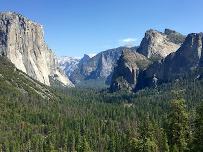
En route to the Yosemite Valley, the iconic Tunnel View showcases El Capitan and Bridalveil Fall rising from the valley, with Half Dome in the background. The massive granite cliffs of Yosemite Valley challenge the body and mind, beckoning climbers from around the world. How these cliffs were formed has baffled geologists for over a century. American Indian legends tell their own stories of how the giants came to be.


The valley is bustling with activity between Yosemite Village and the mix of hiking trails. It was interesting to experience the park from the valley floor after previously being up above. Most of the year, the Merced River flows peacefully through Yosemite Valley. Shrubs and deciduous trees enrich the riverbanks with green ribbons of life. Moist meadows give way to black oak trees that provide nutritious acorns to mule deer, black bears and woodpeckers. A note about crowds: do not attempt to find parking in Yosemite Valley after 10am; snatch the first spot you see, then get out on foot/bike or catch the free shuttle.


At 620', Bridalveil Fall is famous for the mist that wafts off of it when the breeze blows.


El Capitan Meadow provides a close-up look plus a view of Cathedral Rocks. It gave me goose bumps to think of Alex Honnold's recent free-solo of the great wall.


While Yosemite is beautiful at any time of day, I personally think that late afternoon/sunset provides the best lighting. Famous naturalist and conversationist, John Muir, suggested that the High Sierra not be called the Nevada ("snowy") Range, but the Range of Light.

"It is by far the grandest of all the special temples of Nature I was ever permitted to enter."
-John Muir


A few closing thoughts: While I managed to find a cheap flight and hostels, renting a car for a week was a major financial setback. It provided freedom, but I would be wiser to consider alternative transit options in the future, or bring a friend to split the cost with! I also ran into the same lodging issue at Yosemite as I did at Mt. Rainier National Park last month; staying outside the park adds significant time to drive the winding two-lane roads. If weather allows and a permit is secured, camping inside the park would not only save time and money, but also grant the opportunity to witness sunrise, sunset and the night sky. Next time I return to this climbing mecca will be with my climbing shoes and a permit to summit Half Dome!