Thursday, August 27, 2020

Sleeping Beauty Peak

Fall was already in the air by the end of August. The shorter, cooler days smelled like back to school. 


On Wednesday, Red and I drove 2 hours northeast past Trout Lake, WA. The 2.6-mile (1,400' gain) out-and-back trek to Sleeping Beauty Peak is short and sweet, but steep.

From the trailhead, the path gains nearly 1,400' in just 1.3 miles. Luckily, most of the climbing happens under a cool forest canopy of ancient Douglas fir and western hemlock. Eventually, the trail arrives at the bottom of the cliff bands, with a grand view of Mt. Adams--only 11 miles south of its base. 


From there, the path switchbacks up to the top of the rocky summit (4,900') with showy vistas of Mts. Adams, Rainier, St. Helens and Hood. 12pm-1:15pm RT. Date hiked: 8/26/20


Wednesday, August 26, 2020

Maxwell Butte

Date hiked: 8/22/20

It was back to Central Oregon last weekend for a solo hike. Located 2.5 hours southeast of Portland on scenic Highway 22, Maxwell Butte Sno-Park is heavily used during winter for its ski and snowshoe trails. The Maxwell Butte trailhead lies half a mile past the parking lot on Forest Road 080. The 9.7-mile (2,600' gain) out-and-back trek is a lightly-trafficked, challenging trek with a big payoff.

The first section gently climbs through shaded old-growth forest, giving the opportunity to escape the crowds and connect with nature; I saw three small groups on a Saturday afternoon. At 2.4 miles, the small and marshy Twin Lakes are surrounded by wildlife. I recommend following the offline All Trails map to navigate through a few unclear junctions. 

The trail gradually becomes steeper and more exposed, with a series of narrow switchbacks up the extinct volcano. Brightly colored pumice stones confirm that Maxwell Butte was once active. Spectacular views abound of Three Sisters and Mt. Washington. Trekking poles and bug spray advised.

The rocky summit (6,220') is a former fire lookout site that offers a unique view of the Mt. Jefferson Wilderness, including Mt. Jefferson and Three Fingered Jack. Below, the blue pools of the Eight Lakes Basin spread out in the wildfire scar caused by the 2003 B&B Complex Fire.


My new hydration vest allowed me to comfortably trail run back to the car--an unexpected transformation of my four-year passion for hiking. 12pm-3pm RT. 

Saturday, August 22, 2020

Green Lakes

Last weekend, Tom planned a surprise road trip to central Oregon. I was excited to discover what lay in store for us as we drove southeast toward Bend. Our first stop was a short walk to the stunning Salt Creek Falls--Oregon's second highest single-drop waterfall at 286'.


Shortly afterwards, we missed a turn and drove in the wrong direction for an hour before realizing our mistake--the first of many funny things that happened that weekend. We eventually picked up a pair of inflatable stand up paddle boards and arrived at scenic Crescent Lake with Diamond Peak in the background. It felt great to be out on the water, especially on such a hot day. Just before we were about to head back to shore, one of our broken paddles sunk to the bottom of the lake. Luckily, it wasn't too deep to fish it out!


Tom and I spent the evening in downtown Bend. All of the restaurants and breweries had long wait times, but we managed to find a pair of bar stools at Brother Jon's Alehouse to rustle up some grub.

On Sunday, we drove 30 minutes west on the Cascade Lakes Highway to Fall Creek Trailhead. The 9-mile out-and-back (1,150' gain) to Green Lakes is a mostly shaded trail that meanders along a creek with several impressive waterfalls, meadows and views of South Sister, Broken Top and Mt. Bachelor. 


The Green Lakes area is a prime backpacking location with access to many destinations in the Three Sisters Wilderness. We encountered few mosquitos, but lots of butterflies and wildflowers. Great for trail running; crowded on summer weekends. 10am-1pm RT. Dated hiked: 8/16/20.


After the hike, Tom and I made the 3.5-hour trek back to Portland, almost running out of gas along the way! Such a wonderful weekend together.

Saturday, August 8, 2020

Cooper Spur

Date hiked: 8/5/20

The Cloud Cap Trailhead is located 2 hours from Portland, on Mt. Hood near the historic Cloud Cap Inn--a rustic lodge built in the 1890s. Expect rough road the last 9 miles (30 minutes) to the trailhead. The 
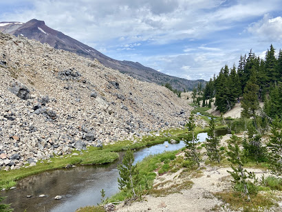
7.1 mile (2,680' gain) summit hike quickly climbs to several soaring viewpoints above the spectacular Eliot Glacier en route to the rocky crest of Cooper Spur, the highest point on Mt. Hood that can be reached by trail. Crowded on summer weekends.


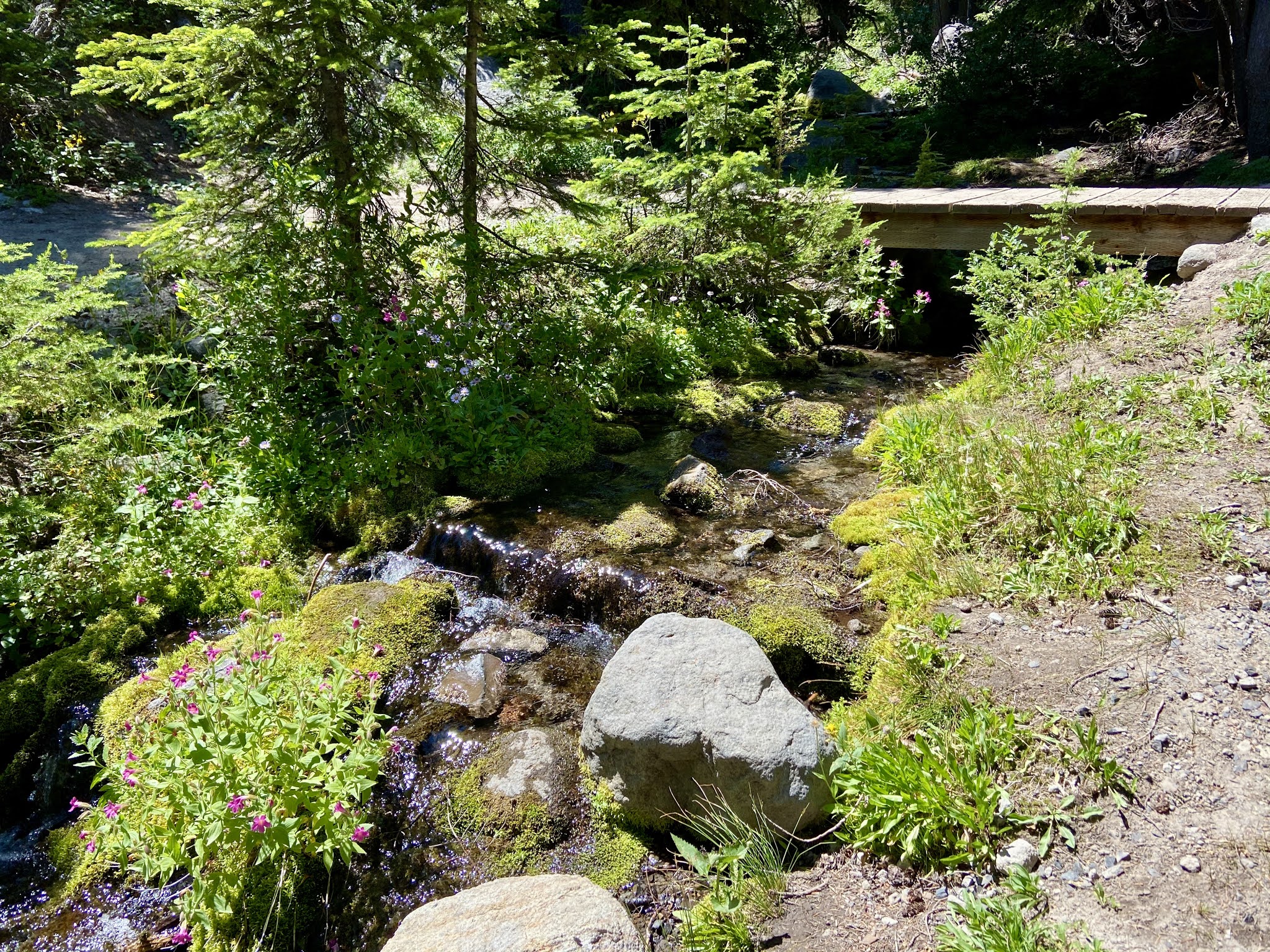
Begin the uphill trek on the Timberline Trail, following the sign to Gnarl Ridge. Pass through an old growth forest of mountain hemlock. In 2008, the Gnarl Fire swept through the Cloud Cap area, burning much of the surrounding forest. The route travels across soft volcanic ash for the first mile. 


The trail then switchbacks up Tilly Jane Canyon amid boulders and scattered alpine wildflowers. Expect lingering snow early in the season and watch for wooden post cairns to guide the way. Turn right at the Tilly Jane Trail junction, following the sign to Cooper Spur. The spur is the hulking, rocky ridge straight ahead.


At 1.2 miles, stop to admire a 70-year-old rustic stone shelter that has survived the avalanches that have destroyed most other shelters along the Timberline Trail (the 40-mile loop around Mt. Hood).


Continue the climb toward the looming crest of Cooper Spur, high into the stark tundra zone of the mountain. Follow a series of broad switchbacks on the increasingly steep shoulder of the spur, with stunning views of the north face of Mt. Hood and the rugged icefalls of the Eliot Glacier. Sunscreen recommended for the high-exposure hike; few mosquitos at such a high elevation.


Nearing the crest, a final set of switchbacks leads to views south of the Newton Clark Glacier before reaching several stone windbreaks at the top of the spur (8,510'). From here, the view extends from Mt. Jefferson to Mt. Rainier, and includes a good portion of the Columbia Plateau to the east.


Follow the ridge as far as Tie-in Rock, a massive boulder where climbers rope up for the big ascent.


Return the same way to the trailhead, or connect to the Tilly Jane Trail for a slightly longer loop hike. 10am-1:30pm RT.

Wednesday, August 5, 2020

Kiteboarding in Hood River

Summer is flying by. I have made an effort to avoid getting wrapped up in the troubling current events, and instead focus on work and hiking. 


When I’m not at the pharmacy or out on the trails, I can be found outside gardening, cycling around town or reading Game of Thrones. Like most events this year, the annual Seattle to Portland bike race went virtual. I was excited to take on the challenge of completing the 200 miles over a 20-day period. I also joined some friends from work on a ride to Dabney State Park. Many people were floating down the Sandy River on the toasty Sunday.


Last Sunday, Tom and I went kiteboarding in Hood River. The 2.5-hour beginner lesson with Kite the Gorge was a blast! Learning in the world class setting of the scenic Columbia River Gorge was surreal. We are both looking forward to getting back out there again soon.


Sunday, August 2, 2020

Paradise Park

Date hiked: 7/29/20

The 12-mile (2,300' gain) lollipop loop from Timberline Lodge to Paradise Park attracts hikers and backpackers for its wildflower displays in July and August. In addition to the colorful mountain vistas, the route passes several waterfalls and offers unique views of the high country south and west of Mt. Hood. Crowds thin out after Zigzag Canyon, especially on weekdays. 


The route begins from the lodge via the Timberline Trail, passing under the ski lifts. On Wednesday morning, the area was buzzing with mountain bikers and skiers--Mt. Hood is skied year-round. Aside from the towering cliffs of the mountain, the view also includes Mt. Jefferson and the Three Sisters far to the south.


After the first easy mile, hike into a small sand canyon. At the edge of Zigzag Canyon, views extend to the meadows of Paradise Park, rugged Mississippi Head and the mesa-like formation at the head of the canyon. Much of the trail is exposed, so get an early start on a hot day.


From here, the trail switchbacks down the ridge line into a shaded forest. At the bottom of the canyon, find a rock hopping route across the rushing Zigzag River, looking upstream for a nice shot of Zigzag Falls.


Head up the west slope of Zigzag Canyon (this trek has several ups and downs). At 4 miles, turn right at the junction to head up the side of the canyon under shady conifers. Cross a few creeks before ascending into the meadows of Paradise Park (6,080'). Cascade mariposa, false hellebore, meadow groundsel, lupine and mountain meadow knotweed are the summer blooms. Luckily it wasn't too buggy, but bring bug spray.


The trail descends to the South Fork of Lost Creek crossing in a flower-filled valley. Towhead babies, the seed heads of pasque flower, stud the grasslands in late summer. The verdant spine of Yocum Ridge lies ahead before the path turns west and winds down through small meadows. Unfortunately, I missed a short spur in this area that looks down into the canyon. Take a left at the Pacific Crest/Paradise Park Loop North Trail junction.


Navigate through shaded woods with small creeks before dropping down the lush side of Rushingwater Creek Canyon. The trail rises up the opposite bank to reenter woods and gradually descend into Lost Creek Canyon with its two waterfalls above the Lost Creek crossing. 


Continue to the edge of Zigzag Canyon, which offers a view along the Cascade crest. The trail switchbacks down to the junction with the Paradise Loop Trail. Stay right and continue back to Timberline Lodge along the Timberline/Pacific Crest Trail. 9:30am-230pm RT.