The Wallowas are a mountain range located between the Blue Mountains and Snake River in northeast Oregon. Here you'll find snowcapped granite peaks, glacial lakes, wildflower meadows, and little-known hiking trails. The "Oregon Alps" are one of the seven wonders of Oregon. Working ranches and canyons surround the remote Eagle Cap Wilderness.
 |
| Aug 4 - 7 |
THURSDAY
Tom and I left after work, driving four hours east to La Grande--a small town instilled with strong morals and values. Eastern Oregon has a rural, country-western flair with genuine, close-knit communities. Carved by the Oregon Trail, the land has changed little since pioneers crossed by wagon. I was first introduced to this last summer in the Steens (southeast Oregon), and it quickly became the theme of this trip. Coupled with its access to pristine backcountry, eastern Oregon is one of the most underrated parts of the state.
Tom and I left after work, driving four hours east to La Grande--a small town instilled with strong morals and values. Eastern Oregon has a rural, country-western flair with genuine, close-knit communities. Carved by the Oregon Trail, the land has changed little since pioneers crossed by wagon. I was first introduced to this last summer in the Steens (southeast Oregon), and it quickly became the theme of this trip. Coupled with its access to pristine backcountry, eastern Oregon is one of the most underrated parts of the state.
Although we arrived later than planned, we stayed with our dear friend Sam, who we met just a few months ago on the Inca Trail. It was a true joy to meet his family and see where he lives. Looking forward to our next reunion!
FRIDAY
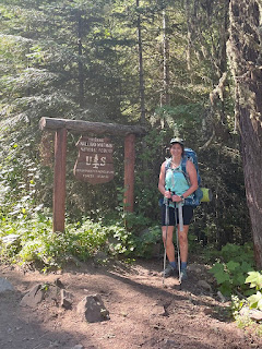
Tom and I drove 1.5 hours to the Wallow Lake Trailhead, relieved not to have to fight for a parking spot. Most hikes in the Eagle Cap Wilderness are relatively long and strenuous, which makes backpacking the best way to explore it. While it can be done as a day hike, the trek to the coveted Ice Lake is 15.4 miles roundtrip (3,380' gain). We set off at 9:30am, winding along Adam Creek under forest canopy before climbing through meadows blooming with wildflowers and scented shrubs. Ascending to the alpine zone leads to Ice Falls and Beauty Falls.


At 7,900', Ice Lake is a tranquil oasis below the Wallowas’ highest ridge. To the north is the long ridge of the Hurwal Divide. The Matterhorn, with its slopes of dark limestone capped by white marble, looms to the west. To the south is a jagged ridge with Craig Mountain. In the evening and early morning, mountain goats graze on the high meadows.
Tom and I reached Ice Lake in 3.5 hours, with aching shoulders from carrying our heavy packs. We set up camp in a secluded part of the peninsula. Despite it being one of the most popular areas of the Wallowas, we found it relatively empty compared to areas closer to Portland. We fueled up (think PB & Js) and explored the lakeshore before a brief hail storm rolled in. It cleared up quickly, but we sheltered inside the tent for a good part of the afternoon to hide from the pesky mosquitos; incentive to come back in early fall (also to see the aspen trees change color).
SATURDAY
The Matterhorn is a 3.6-mile trip from Ice Lake. The trail climbs 1,980' in 1.8 miles, making for a very steep climb. At 9,826', it is just 12' shorter than Wallowas’ highest summit, Sacajawea Peak. Trekking poles and a liter of water are recommended.
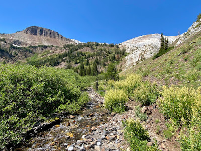
Tom and I reluctantly left our warm sleeping bags and set out at 9am, following a boot path that leads along a creek tumbling down an alpine slope. I filled my water bottle from the icy creek. After the meadow, the granite benches become less vegetated as you ascend into the high alpine zone. Loose, dark limestone transitions to light marble on the summit ridge.
We summited in 1.5 hours. On a clear day, views extend along the expanse of the Wallowas. The endless peaks and rugged terrain reminded me of a Colorado vista. Perfection.
While tempting to follow the ridge to bag Sacajawea Peak, this approach is not advised. Returning from the summit, we negotiated the path with a couple mountain goats, and detoured to visit the turquoise tarn in the cirque below the summit ridge. From the edge of the bowl, Ice Lake sparkles below. Some route finding is needed to connect with the boot path that leads down to the lake; looks for cairns.
We returned to the lake shortly before 1pm to change clothes, grab a bite to eat, and break down camp. It took us about 3 hours to hike out. After trekking 19 miles in two days, my dogs were barking; good socks and shoes are key.
This was my first successful and true backpacking experience. The biggest lesson was to pack less food and water. While I still prefer day hiking, I do appreciate the tradeoffs and will likely continue to seek out backpacking excursions in the future.


We stayed in a bnb 20 minutes north in the small town of Enterprise. I was over the moon to clean and be cleaned. That evening, we walked to Terminal Gravity Brewing for beers and grub.
SUNDAY
Tom and I returned to Wallowa Lake in the morning. He went for a long run while I paddled on my SUP. I couldn't believe that I practically had the serene lake to myself at 9am on a Sunday. I was also surprised to see floating docks along the edge of the lake. The dramatic view of the mountains reminded me of the small Coloradan town, Ouray--coincidentally the "Switzerland of America." The perfect ending to a stellar weekend.
This was a a great intro to northeast Oregon. Next time, I would like to hike Eagle Cap and ride the gondola from Wallow Lake Village to Mt. Howard. It would enjoy taking time to explore the quaint town of Joseph and continue on the Hells Canyon Scenic Byway to the canyon overlook.


