Many climbers attempt this mountain as a two-day backpack trip by camping at Lunch Counter. However, my friend Kyle and I opted for an arduous day hike. We left Portland around 9:30 Saturday night, driving 2.5 hours northeast to Cold Springs Campground. The last three miles to the trailhead are very rough and narrow.
We hit the trail at midnight, following an old road bed through the 2012 Cascade Creek burn zone. The first mile was snow-free and relatively flat.
 |
| Most of the ascent was guided only by the light from the stars and our headlamps; pictures were taken on the way back. |

The terrain beyond Morrison Creek becomes rocky and rough with loose tread. We traversed this section and arrived atop a ridge line.

 |
| St. Helens |
The trail climbed relentlessly to the Crescent Glacier snowfields below Lunch Counter. In my sleepless zombie-state, every ridge seemed a mirage that never grew closer.

Strapping on crampons, we continued up to Lunch Counter, where climbers were waking up to bag the summit. At this point, I could start to make out the silhouette of the looming mountain above. I could also smell wildfire smoke from nearby Tunnel Five Fire.

From Lunch Counter, it's another grueling climb to Pikers Peak--a false summit that can take hours to reach. Fortunately, we were blessed with good weather, and the snow was still study from cold overnight temperatures. The sky gradually lightened with beautiful sunrise colors, revealing how far we'd come, and what lay ahead.


 |
| Mountain shadow |
It's a hefty push to the summit cone with thin air towards the top.


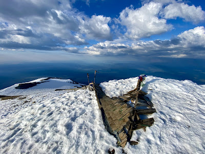
We were the second group to summit at 7am. From 12,276', panoramic views and peaks spread out for miles. I could see Mts. Hood, St. Helens, and Rainier. On a clear day, you can see all the way north to Mt. Baker and south to Mt. Bachelor. It was very windy and cold, and a line of people were close behind, so we only stayed for a few minutes.


When the conditions are right, climbers usually prefer to glissade on the way down to save time and effort. Glissading is sliding down a snow chute on your bum! It can be fun, but requires you to know how to brake and self-arrest with an ice axe. I tried it, but felt unable to control my speed and ultimately decided to walk down. Luckily, the snow had softened by this time, and it was easy enough to plunge step into the boot path left from other climbers.

It was a relief when we descended low enough to remove our crampons and hike back to the car. Along the way, I saw purple wildflowers, butterflies, and deer. Adams is also home to mountain goats.


Completely exhausted, we reached the car at 11:30am. After a change of clothes and power nap, Kyle drove us back to Portland for a much needed shower and sleep!
I have officially completed the Guardian Peaks, which consist of the three volcanic mountains that are visible from Portland: Wy'east (Hood), Pahto (Adams), and Loowit (St. Helens). Adams was a great experience to build my confidence in mountaineering. Ideally, I would have climbed Adams before Hood, since it is less steep and technical. However, Adams is still a slog, and 1,000' higher than Hood!